
The Walk in Hyeres
Hyéres was deposited by a celestial grace, with the multiple hollows of landscapes. Bordered in the south by the Mediterranean, true sea-maitresse, in north by the so expensive hills with Provence, in the east by the superb solid mass of maures, the city is also surrounded, a such eternal pressure, by a green campaign.
Hyères is one of the most extended communes of France, it extends since the valley from Sauvebonne (which delimits Maures) to the islands of Gold. Thus a very rich diversity of landscape there is found: drill, range, hills, marsh...
Some figures:
surface = 13 238 hectares; including 4300 hectares of drills and 1284 ha for the islands
30km in its greater width
39 kilometres of dimensions
The Walk that we propose to you, will pass by all these places which marked the history of the town of hyeres.
You can choose with the map to return to you directly on the place of the walk.
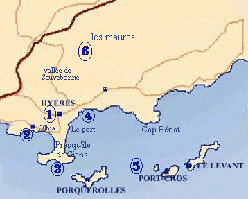
We will try to present to you through this walk the history of our city, since the Gallo-Roman time until today. For that we divided the city into six sectors:
- 1 the town of Hyeres: it is divided into plusior
districts
- the old city, the historical medieval center
- the centre town
- the district of the station
- olbus riquier
- the Paradise
- ...
- 2 Olbia: the archeological site of the city Greek
at the origin of our city
- 3 Almost the ille of Giens: its double tombolo is
single in Europe
- 4 the dimension: with the port of hyeres, Aygade
and the saline ones.
- 5 Gold islands
- Porquerolles
- Port-Cros
- Raising
- 6 Maures: it is here that starts this drill with the borrels and the valley of Sauvebonne.
And can be that after all these efforts you deserve small a casanis well...